Tuesday, September 13, 2016

Greenland (it's not so green)

 Erik the Red, who I didn't mention in my Iceland post (something has to wait for the book!), is the one who named Greenland in the hopes of luring settlers.  If ever a country should have been called 'Iceland' this is the place with 80% of the land mass covered in ice.  I visited the east coast where only 3,000 of the countries 57,000 inhabitants live, many in tiny villages along the coast.  No roads connect the villages so helicopters & boats come in pretty handy.  As we flew into Kulusuk (a town of about 250 people), you could immediately see why not many people live here.

We changed to a small helicopter (took a couple of trips for our group of 12) and flew over to the town of Tasiilaq for two nights.  Tasiilaq is the largest town on the east coast with a population of about 2,000.   Do the math and you'll see that doesn't leave many who are spread out in other small villages.
 
The only animals that we saw were sled dogs (and a rare cat).  The dogs are considered work animals, not pets, and all we saw were tied up in the yards. 

We passed by the town's cemetery as we headed off on a hike into a nearby valley.  In the Inuit tradition, no names appear on the crosses.  Instead, the name of the deceased is passed on to another thus living on to the next generation.

The brightly colored homes dot the barren landscape.  Some, as with the red one below, have fish drying on simple racks attached to the house.  Most people work in a service-related job or are hunters of seals and the occasional polar bear. Permits are only for those who make their sole living as hunters.
 
The view from our hotel (too bad the panoramic shots don't spread out here). 

A boat ride along the coast allowed us to see some icebergs up close.


The helicopter rides gave us a good chance for some aerial views.

The northern lights were active all 3 nights, but most particularly on our second night in Tasiilaq when they filled the skies.  I was unable to get a long enough exposure on my camera to capture the lights, but one of the gals on the trip graciously shared her photos. 


 I loved the cotton grass blowing in the wind.

Walking back from the store on Kulusuk where we spent our final night.


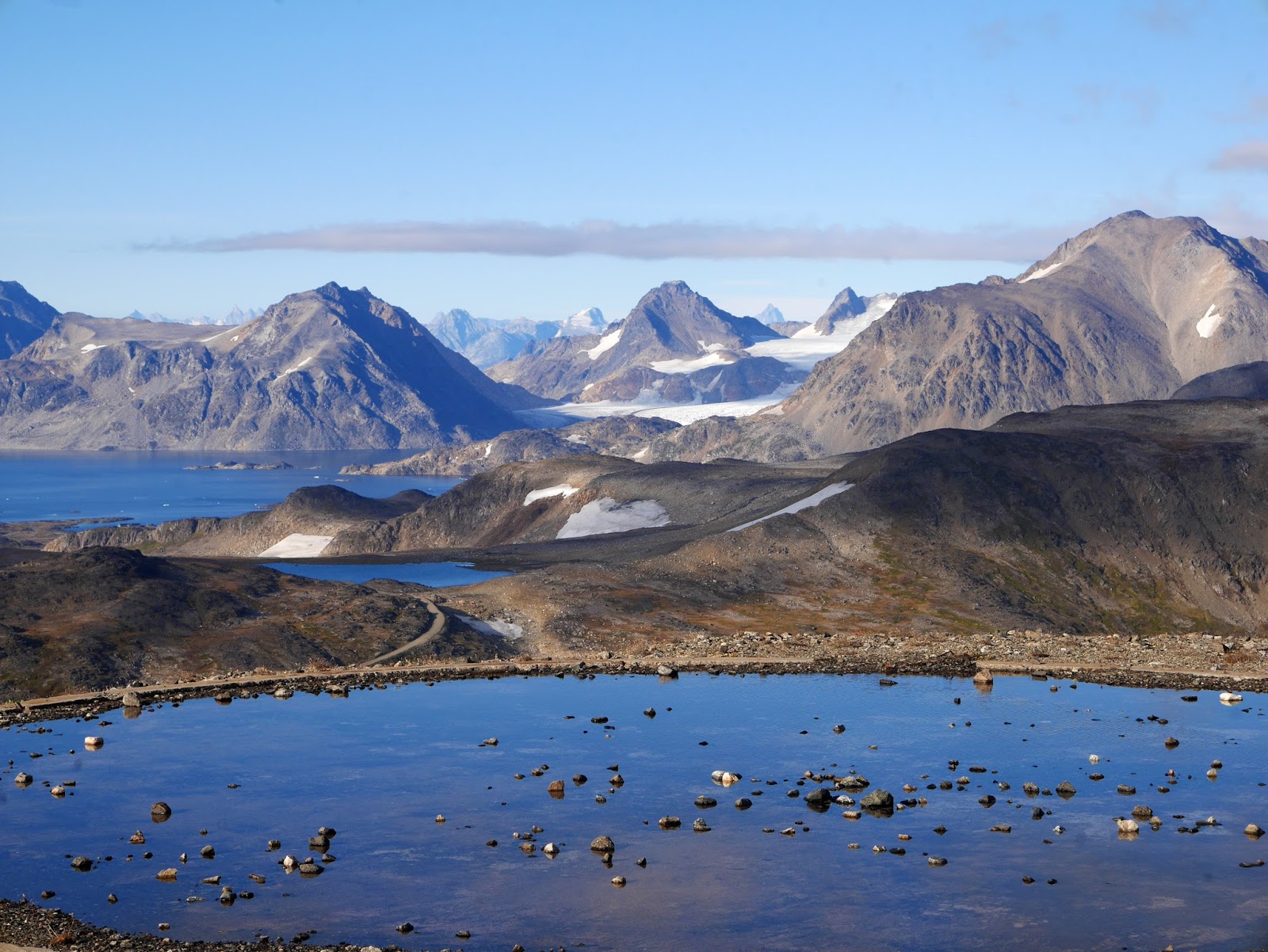
Views from a mountain top.  We took one of the 3 (yes, 3) vehicles on the island of Kulusuk up into the mountains to where an American military base had once been. Lovely views (but still no green!).
 
Iceland and Greenland were so different, but both had such beauty.  Very glad to have seen them!

Saturday, September 10, 2016

Iceland... part 2

Iceland, the land of ice and fire.  Isn't that the truth!  The country sits on one of earth's most geothermal active areas and yet glaciers are still found intermixed with volcanos. All of this makes for fascinating landscapes with hot springs, boiling mud pots and geysers all over the country.  In the top left photo below, behind where I'm standing to take the picture, sits the now (mostly) inactive 'Geysir', the geyser that all other geysers are named for. Sorry, but I'm showing one that's actually doing something :).
 
 And of course, the place everyone goes to, the Blue Lagoon.
  
Coastal areas change from dramatic rock formations such as these on the Snaefellsnes Penisula to serene coves.
  
 
There were more puffins on the mainland coast too - these were nesting on a cliff.  Not the best photos but I was happy to get a shot of one showing off his herring catch.
 
If you're looking for waterfalls, this the place to be.  A few examples below starting with Hraunfossar, a 2,900-foot stretch of lava where clear springs filter through the volcanic rocks and into a river of glacier run-off.
 
Godafoss Falls

Gullfoss Falls

Skógafoss Falls
 
A few more animals of the sea. We saw 15 whales in the Evjafjorour fjord, then did a bit of fishing (I caught a cod!).

At another location, the seals were hanging out just off-shore.
 
In Cuba I was obsessed with the cars, here it was the horses - they were everywhere!  So beautiful.


Even went for a ride!

 
One of my favorite locations was just outside of the southern town of Vik.  We took a jeep tour up to the Myrdalsjokull glacier, which sits atop the Katla volcano.  Katla is overdue for an eruption and is likely to trigger an enormous flash flood - potential enough to destroy the town.  The only building that would likely survive is a church that sites high on a hill.  The townspeople know the drill - in case of eruption, go to the church.  Two days after we visited there was a good size earthquake.  Hmm...    
I loved the moss-covered hills in contrast to the dark black lava.

The glacier is straight ahead.

Our trusty guide climbed the glacier to chop out some crystal clear ice.  See him about 1/2 way up?  He was nice enough to bring some vodka to pour over the ice :).
 
Before I close this out, a word about Reykjavik.  What a pretty city!  We walked quite a bit of it, including stopping by Harpa, the city's concert hall made of geometric shaped glass panels.  Lots of photos taken there!
 
 
The Lutheran Church is the largest in Iceland and towers over the city.
 
I'll close this trip out soon with some photos from Greenland - a land vastly different from Iceland.

Wednesday, September 7, 2016

Iceland

I spent 2 1/2 weeks in Iceland & Greenland from August 17 though Sept 3rd.  The first stop was Heimaey Island, the only one of the Westman Islands that's inhabited.   Fields of grazing horses and sheep, sea-side cliffs and two volcanoes, all grace this lovely island.   At first look you would never know that a 1973 eruption led to the evacuation of the entire population of 5 thousand people and destroyed around 400 homes.  Rough seas the evening of the eruption, kept the fishing fleet in port. This turned out to be the key factor in saving everyone by having enough transport vessels.  It was fascinating talking to locals about their experiences that night and then salvaging the city in the aftermath.
 
The volcanoes Eldfell and and Helgafell, forming a backdrop to the town, look deceptively innocuous.  I hiked to the top of Eldfell, the one on the left, and you could clearly see the side that blew out during the eruption.

 
Hiking over the lava flow where signs have been posted to remind locals where streets were once located.

Posts placed around the town are stark reminders of how deep the ash was that fell on the town.  A museum of remembrance has a barrel of the ash with a small shovel to help visitors understand how coarse and heavy this ash was.  What an enormous task it must have been to clean up the town.      
 
 
You can see from the photo below how narrow the harbor entrance is now - the end of the lava flow is on the right.   A never before tried technique was used to cool the advancing lava flow by pumping sea water onto it and successfully preventing the loss of the harbor.

 
I took a cruise around the island, then the next day hiked along this stretch of the island and to the green building seen in the photo below - a viewing platform to watch puffins from.  It was a good spot, although some of the cliffs before this spot were best for viewing these cute birds. 

I loved the hike along the coast.  Just beautiful. And so many puffins!

Around 8 million puffins migrate to Heimaey every summer.  Although the puffin population has been decreasing in recent years due to warmer waters and invading fish species impacting their food supply, the numbers did rebound this year.
 
 
Grazing sheep can be found just about anywhere - including the most seemingly impossible vertical cliffs.   I love the way they follow established paths.   
 

Next up, mainland Iceland...

Monday, May 2, 2016

Alaska... part 2

Continuing on with the Alaska tale, we cruised on to the Hubbard Glacier in Disenchantment Bay then on to Glacier Bay the next day.  Nothing for fun icebergs like I saw in Antarctica and no major calving to be seen, but just listening to the glacier is as it stresses, shifts and cracks is fascinating.
 
The day in Glacier Bay was raining, which didn't make for exciting photos, so I'll spare you there and move on to Skagway. The day in Skagway was the best both weather-wise and the excursion.  I took the White Pass Scenic Railway up into the mountains and over the Canadian border to British Columbia.  Just beautiful scenery the entire way.


The Yukon Suspension Bridge at the Tutshi Canyon.


The town of Skagway has a long history from the days of the gold boom when it was apparently a wild and crazy place. 


After Skagway we stopped in Juneau and Ketchikan, both nice little towns.  Unfortunately the weather was quite miserable both days with blowing rain.  I walked around with friends, had some more crab and made the best of it.  Photo below is leaving Ketchikan...as the rain was finally coming to an end.  
 
Today, as we cruise towards Vancouver, the weather has been beautiful and the scenery stunning.  I need to see more to the Pacific Northwest one of these days.